XGRIDS Premium Portal Cam
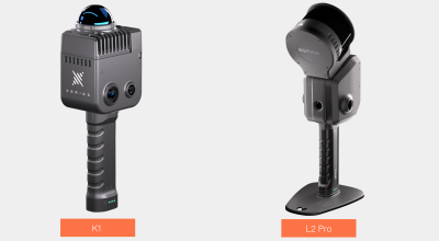
| BRAND | XGRIDS |
|---|---|
| MODEL | PortalCam (Premium Kit) |
FINANCE AND BUY OPTIONS
Rent for short-term needs, finance the purchase by leasing, or just purchase outright.

WANT MORE OPTIONS?
Get multiple quotes to rent, finance or buy from
29 Suppliers of metrology equipment
* Advertised finance rates subject to application and credit approval.
EQUIPMENT FINANCING REINVENTED
Competing lenders. More approvals. Lower rates.
Finance this as low as
$145/mo
*60 month lease
60 Second Application
Shop competitive rate offers
from the nation's top equipment lenders
from the nation's top equipment lenders
How it works
Submit a 60-second application
Receive offers from competing lenders
Choose the best offer