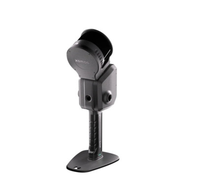
XGRIDS Lixel L2 Pro Handheld LiDAR SLAM Scanner


| BRAND | XGRIDS |
|---|---|
| MODEL | Lixel L2 Pro |
- High-Precision SLAM Integration: Combines LiDAR, visual, and IMU data for reliable, real-time mapping.
- On-Device AI Processing: Produces clean, detailed point clouds instantly without extensive post-processing.
- Real-Time Color Point Clouds: Captures visually rich, true-color 3D data for immersive visualization.
- RTK & Control Point Support: Enables survey-grade absolute positioning and enhanced accuracy.
- Compact, Handheld Design: Lightweight and ergonomic for effortless mobility and field use.
- User-Friendly Software Suite: Seamless data management and processing via integrated app and desktop platform.
- Versatile Applications: Ideal for BIM, surveying, digital twins, VFX, smart city modeling, forestry, and inspection.
- Efficient Mobility: Optimized for rapid scanning in confined or fast-changing environments.
- Technology: SLAM (Simultaneous Localization and Mapping) using LiDAR + Visual + IMU fusion
- Processing: On-device AI for real-time 3D point cloud generation
- Output: Colored point clouds and Gaussian “splats”
- Positioning Support: RTK and control point compatible
- Primary Applications:
- Surveying / Topography / Civil Engineering
- Scan-to-BIM / Architectural Documentation
- Digital Twins / Smart City Mapping
- Cultural Heritage / Archaeology
- Film / VFX / Environmental Monitoring
- Known Constraints:
- Slightly lower precision than tripod-mounted scanners for ultra-high-accuracy tasks
- IMU performance may decrease in steep or narrow vertical environments
- Panoramic image alignment may require manual control points in photogrammetry workflows
One Request, Multiple Quotes.
RENT, FINANCE AND BUY OPTIONS
Rent for short-term needs, finance the purchase by leasing, or just purchase outright.

|
| FINANCING RATES |
|---|
| $538.74/mo 60mo |
| $651.00/mo 48mo |
| $834.39/mo 36mo |
| $1,218.67/mo 24mo |
| Equipment Condition: New |
|
Leasing equipment on KWIPPED lets you finance the purchase of equipment by offering a $1 buyout or letting you keep the equipment at the end of the lease.
|
WANT MORE OPTIONS?
Get multiple quotes to rent, finance or buy from
44 Suppliers of metrology equipment
This is going to be easy!
When do you need your rental? We will use the best rate for your timeframe.
| RENTAL RATES
Rental Terms
|
|---|
| $6,000.00/mo |
| $1,950.00/wk |
| $850.00/day |
|
Content loaded with Ajax...
|
First thing's first...
Tell us who you are.
Schedule your rental
Finalize your order and receive your equipment.
This supplier does not rent in your city.
However, we can still help you!
You can go back and see if there is another supplier who services your area, or you can request custom quotes from the KWIPPED network.
EQUIPMENT FINANCING REINVENTED
Would you like to add a guarantor?
Lenders will usually not approve an application without a guarantor if the business is less than 9 years old.
EQUIPMENT FINANCING REINVENTED
Guarantor information
A guarantor is required for sole proprietorships or businesses less than 9 years old. Rest assured, your personal information is safe and secure. We encrypt personal identifiable information such as your SSN#.
EQUIPMENT FINANCING REINVENTED
That's all there is to it!
Once your app is created, you have the option to add additional equipment from the KWIPPED marketplace under one lease.
By submitting this application, the undersigned individual, who is either a principal of the credit applicant or a personal guarantor of its obligations, provides instruction to KWIPPED or its designees (any assignee or potential assignee thereof) authorizing review of his/her credit profile from a national credit bureau, as well as obtaining bank and/or other credit information as required. Such authorization shall extend to obtaining a credit profile in considering this application subsequently for the purposes of update, renewal or extension of such credit or additional credit and for reviewing or collecting the resulting account. By submission of this form, I/we affirm my/our identity as the respective individual/s identified in the application received.

